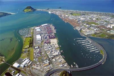
The Port of Tauranga lies 75 miles south of the beautiful conch shell beaches of the Coromandel peninsula on the east coast of North Island, New Zealand. The attractive port is entered through a deep water channel into Tauranga Harbour, an extensive area of 19,900 hectares of shallow water and mudflats to the west of the modern port. Matakana Island forms a long perimeter barrier to the sea to the north of the entrance channel, and the sea has also formed a shallow inlet at the north of Matakana Island into Tauranga (pronounced ‘Tow-rang-ah’) harbour. The 761 feet high extinct volcanic cone of Mount Maunganui, known as Mauao, rises above the entrance channel on its south side, and has hot saltwater pools at its base, with the sandy strip of land next to it is known as Mount Manganui community, a suburb of Tauranga. This local community remained independent of Tauranga until the 1989 local government reforms. The Tauranga Harbour Bridge was opened in 1988 and has helped this joining together process by uniting the Mount Maunganui and Tauranga communities. The walking trails around Mauao volcanic peak provide grandstand views of the shipping entering and leaving Tauranga port.
The tourist areas of Ocean Beach, Omanu and Arataki in the eastern coastal strip of Tauranga and the Bay of Plenty have a lively waterfront area and some impressive beaches. The Bay of Plenty occupies a huge area of land between the Coromandel peninsula and the East Cape, with rich farmland famous for the growing of kiwifruits and tangelos. The Bay of Plenty is mostly Maori country as most of the first Maori to reach New Zealand arrived here in their great ‘waka’ canoes. The racial mix of the current Tauranga population of 120,000 people has only gradually changed with the influx of Europeans.
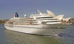
The Port of Tauranga is now the largest port in New Zealand in terms of cargo handled, and is the only natural harbour between Auckland and Wellington offering good shelter in all weather conditions. In 2014 it handled 19.74 million tonnes of cargo (13.35 million tonnes exports and 6.39 million tonnes imports), of which the greatest cargo by far was the 8.3 million tonnes of logs, wood chips, and forestry products exported to the Asia-Pacific region. Some 1.56 million tonnes of dairy products and 0.69 million tonnes of fruit particularly kiwifruit and tangelos was also exported, and oil product imports were 1.3 million tonnes and fertiliser imports were 0.5 million tonnes. Ninety cruise ships visited the port during the six month cruise season from October 2015 to April 2016, with their estimated 300,000 cruise passengers enjoying sightseeing in the Bay of Plenty or visiting the hot springs and geysers of the Taupo volcanic area of central North Island. Three cruise ships can be moored at any one time along the Mount Maunganui wharves of total length 2,055 metres, and the other principal wharves are the Tanker Terminal of length 250 metres, and the impressive new Sulphur Point Container Terminal with three berths and a length of over 770 metres. This container terminal handled 850,000 TEU of containers imported or exported, with another 140,000 TEU of containers transhipped.

Subscribe today to read the full article!
Simply click below to subscribe and not only read the full article instantly, but gain unparalleled access to the specialist magazine for shipping enthusiasts.

Comments
Sorry, comments are closed for this item